Hide panel
Ecosystem type
Select
Thank you! Your submission has been received!
Oops! Something went wrong while submitting the form.
Land-use challenge
Select
Thank you! Your submission has been received!
Oops! Something went wrong while submitting the form.
NbS approach
Select
Thank you! Your submission has been received!
Oops! Something went wrong while submitting the form.
Clear allAbout the libraryGuide
Freshwater bodies and Rivers
Waterbodies degradation
Wetland and water management

Grensmaas (Border Meuse) River Restoration and Rewilding Project

Location

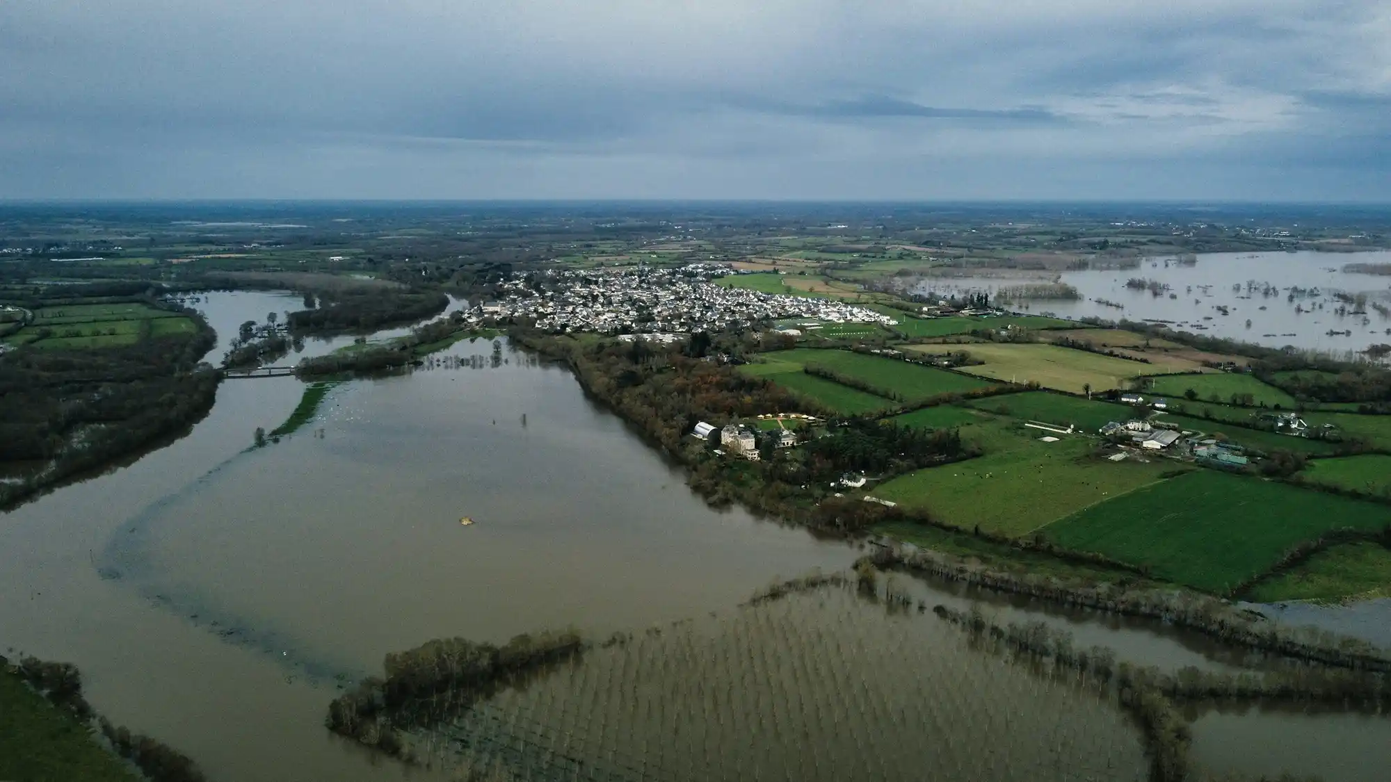
A section of the River Meuse at the border between The Netherlands and Belgium, between Maastricht (NL) and Maaseik (BE)

Status

Project ended

Scale

Landscape level

The Grensmaas Project is the Netherlands’ largest river restoration and rewilding initiative, transforming 45 km of the Meuse River course into a wider, more natural, and flood-resilient system. Through an innovative public-private partnership involving the Consortium Grensmaas, gravel extraction companies, civil engineers, and conservation groups (notably Natuurmonumenten), the project combines flood protection, ecological restoration, and economic self-financing via the sale of extracted gravel. The resulting landscape forms part of the RivierPark Maasvallei, with ~1,000 hectares of restored nature, ~300 hectares of widened riverbed, and 200 hectares of naturalistic grazing.

The Meuse basin in South Limburg has long been prone to flooding, with catastrophic events in 1993 and 1995 prompting demands for improved flood defences. The Grensmaas section (the section of the Meuse River at the border between The Netherlands and Belgium), is a unique area of this river, being the only Dutch river stretch without shipping traffic. As such, it offered both ecological and engineering potential for a project aimed at improving flooding defences while renaturalizing a part of the river. Earlier government plans for deep gravel mining were replaced by a “Future of Gravel River (FoGR)” rewilding vision (developed by Stroming Ltd, BirdLife Netherlands, and WWF) that integrated shallow gravel extraction with river restoration. Political momentum following the 1990s floods embedded the project into the Delta Plan for Large Rivers, and allowed for its kick-off.

Highlights

  • Scale: 45 km of restored river corridor and ~2,000 hectares of dynamic riverine landscape.
  • Flood protection: widening of the river bed by ~300 hectares, with 12 km of raised and reinforced dikes, lowering flood risk for tens of thousands of residents.
  • Hydrological performance: designed for 1-in-250-year flood events; proven successful during the July 2021 floods.
  • Nature restoration: 200 hectares of riparian lands under natural grazing; reintroduction of beaver (Castor fiber) and otter (Lutra lutra); recolonization of diverse riverine flora and fauna.
  • Bilateral collaboration: Dutch and Belgian authorities coordinated approvals (2001); forms part of the transboundary RivierPark Maasvallei (Natural Park Meuse Valley).
  • Recreation and economy: 2 million visitors annually, generating about €1 billion revenue per year for the regional economy.

Timeline

  • 1980s: Meuse identified as non-navigable river system with gravel-mining potential.
  • 1989: Future of Gravel River (FoGR) plan developed by Stroming Ltd, BirdLife Netherlands, and WWF.
  • 1993 - 1995: Major floods catalyse political support.
  • 2001: Binational approval (NL–BE).
  • 2005-2008: Project implementation begins (BE first, NL after).
  • 2017: Core flood safety objectives achieved, with villages in the area of intervention declared protected.
  • 2021: Flood test confirms performance during extreme rainfall.
  • 2027: Final implementation phase (Koeweide/Trierveld, Sittard-Geleen) to be concluded.

About the intervention

A nature-based river restoration integrating flood safety, economic extraction, and ecological regeneration. The approach transforms a former industrial gravel zone into a dynamic braided river that absorbs floods, restores biodiversity, and generates economic value, all without public financing.

Intervention details

The intervention combined river restoration with flood protection across a 45 km stretch of the Grensmaas/Border Meuse course, between Maastricht and Echt-Susteren, at the border between The Netherlands and Belgium. Delivery in The Netherlands is led by Consortium Grensmaas, which brings together the gravel extraction sector, civil engineering contractors and the private conservation organisation Natuurmonumenten. Early planning was driven by the local natural history society (Natuurhistorisch Genootschap), BirdLife Netherlands (Vogelbescherming) and Stroming Ltd, building an alternative to deep pit mining based on Plan Stork principles and promoted through a wider communication campaign.

Implementation used shallow gravel excavation to physically reshape the river system while extracting gravel from the existing riverbed. This widened the river corridor, lowered riverbanks and expanded the floodplain. In the Dutch corridor, this included widening the river basin by around 300 hectares. In parallel, conventional flood defence works were delivered where needed, including strengthening and raising dikes for about 12 km. The extracted gravel volumes were large (about 50 million tonnes), reflecting the role of gravel removal as the main lever to create a wider, free-flowing river.

Rewilding measures were implemented to accelerate ecological regeneration and maintain open, dynamic river habitats. More than 200 hectares of riverside land were placed under naturalistic grazing regimes, with ARK Nature holding grazing rights on over 200 hectares and introducing natural grazing. Beaver (Castor fiber) and otter (Lutra lutra) were reintroduced and subsequently tracked through monitoring.

Governance followed staged approval and design processes. The Provincial Government of Limburg established a dedicated project organisation with the responsible authorities (Provincial Government of Limburg, LNV and V&W) to develop the plan and start preparatory planning, supported by a technical design group to model hydrological, morphological and ecological measures and assess feasibility. Cross-border approval by Dutch and Belgian authorities was secured in 2001, with implementation starting in 2005 (Belgium) and 2008 (The Netherlands). Floods in 1993 and 1995 strengthened political support and helped anchor the approach in the Dutch Delta Plan for Large Rivers.

Implementation has been phased by location. Work is now concentrated on the final location at Koeweide/Trierveld in Sittard-Geleen, with other locations completed, and is scheduled to continue until the end of 2027. Some early community resistance is reported to have reduced over time as recreation, environmental and flood defence benefits became apparent.

Key stakeholders

  • Consortium Grensmaas
  • Gravel extraction firms, civil engineering contractors
  • Natuurmonumenten (conservation NGO)
  • Province of Limburg (PoL); Dutch Ministries of Agriculture (LNV) and Infrastructure (V&W); Belgian partners in Maasvallei. NGOs & Initiators: Natuurhistorisch Genootschap, Stroming Ltd, BirdLife Netherlands (Vogelbescherming), WWF Netherlands, ARK Nature. Local residents and municipalities (e.g., Maastricht, Echt-Susteren, Sittard-Geleen) Dutch and Belgian agencies monitoring hydrology, geomorphology, and biodiversity.

Financial metrics

Funding sources

  • Self-financing through gravel extraction and sale (54 million tonnes), with no direct taxpayer burden, as revenues from sand and gravel extraction finance both restoration and flood safety measures
  • Consortium-managed delivery; costs shared among extraction companies, engineers, and conservation bodies

Budget

  • €550-700 million

Outcomes

Environmental

  • Climate adaptation: Flood safety targets were met and tested under real-world scenario during 2021 high-water events.
  • Ecosystem health: High ecological recovery of riverine vegetation, fish, amphibians, and birds.
  • River now supports braided gravel habitats and serves as an ecological corridor linking upstream and downstream Meuse sections.
  • Species reintroductions: Successful re-establishment of beaver and otter populations; positive monitoring data on flora and fauna recolonization.

Social

  • Flood safety: Tens of thousands of households along the Meuse now secured from severe floods.
  • Recreation & tourism: Integration into RivierPark Maasvallei, a major cross-border ecotourism destination.
  • Community acceptance: Early opposition replaced by local pride as benefits became visible (identity, recreation, heritage).
  • Employment: Long-term jobs in construction, ecological management, tourism, and hospitality.

Economic

  • Self-sustaining financing model: nature restoration funded entirely through gravel revenues.
  • Regional growth: Tourism and leisure sectors generate about €1 billion annually from visits and activities in the restored area.
  • Avoided costs: Reduced flood damages and insurance liabilities across South Limburg.

Risks and considerations

  • Need for ongoing maintenance as climate extremes intensify.
  • Future upstream-downstream coordination to prevent uneven flood loads.
  • Habitat succession in restored gravel areas requires adaptive management.

Lessons learned

  • Self-financing models can deliver large-scale NbS with minor or null public investments.
  • Integration of industry and conservation (gravel companies + NGOs) is feasible when mutual benefit is clear.
  • Flood safety + biodiversity restoration can be combined at scale.
  • Local trust-building transforms early opposition into community ownership.
  • Cross-border cooperation ensures ecological connectivity and governance continuity.

Sources

For Reference

  1. Nature-based Solutions Initiative, 2025.
  2. Consortium Greenmass BV, 2025.

Related EU projects

Information not available yet.