West Exmoor, Devon & Somerset, United Kingdom
Ongoing implementation
Landscape level
Since 2019, the National Trust’s West Exmoor team has been transforming a rewilding area described as 600 ha, within a wider West Exmoor landholding described as 1,821 ha, by re-wetting drained ground, reinstating dynamic grazing with cattle, ponies and pigs, diversifying even-aged oak woods, and opening access. The programme aims to slow water, rebuild soils and habitats, increase carbon capture and support nature-based enterprise, while complementary coast-to-moor projects expand woodland, wetlands and species-rich grassland at landscape scale.
Historic burning, drainage and intensive sheep grazing left Exmoor’s coastal heath and valley systems with thin, compacted soils, simplified vegetation (blankets of single-aged heather and gorse) and incised, fast-flowing streams. Oak-dominated, even-aged woods reflect an industrial legacy, reducing structural and species diversity. The result was rapid runoff, erosion risk, habitat fragmentation and declining wildlife. The programme restores natural processes (slower water, natural regeneration, mixed grazing, woodland structural diversity) to recover biodiversity, store more carbon and improve resilience, while creating fair public access and local economic opportunities.
The programme restores natural processes across 600 ha and adjacent landscapes by re-wetting drained ground, adopting conservation grazing (cattle, ponies, pigs), encouraging scrub and wood-pasture mosaics, and restructuring even-aged woods through glades, coppice and pollards. Complementary projects create new woodland, wetland and meadows and deploy leaky dams and ponds to slow flow. Public access is expanded, species recovery actions are targeted, and nature-based enterprises support financial viability.
The intervention on West Exmoor was implemented as a long-term, landscape-scale shift towards restoring natural processes across a large landholding (reported as 1,821 hectares under National Trust care), spanning uplands, grassland, woodland, water and coastal habitats. The approach moved away from managing discrete habitat “blocks” and instead used a coordinated set of actions to create a more structurally diverse and dynamic mosaic, while expanding public access.
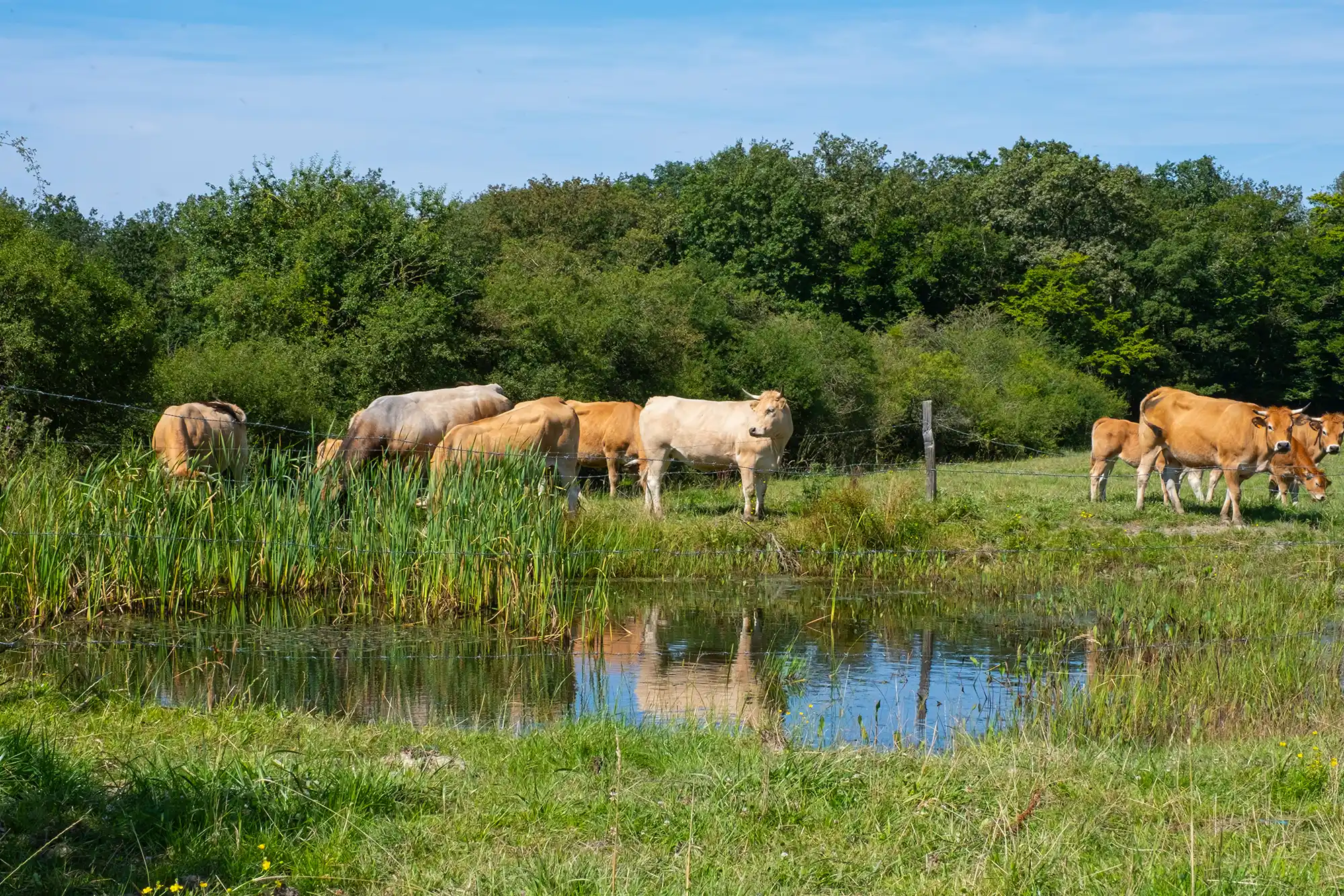
Grazing pressure was deliberately reduced by removing intensive sheep grazing and replacing it with low numbers of free-roaming livestock: Old English Longhorn cattle, Mangalitsa pigs and Exmoor ponies (with red deer present naturally). These animals were used as functional ecosystem drivers: cattle were used to break through dense vegetation and maintain open glades; pigs were used for rootling to create bare ground patches and open up thick grass swards; and wallowing animals (including buffalo in the vision described) were used to help prevent pool siltation and maintain open-water habitat complexity. Across the wider Exmoor Coast work, cattle were fitted with GPS “no-fence” collars to contain them using virtual boundaries rather than physical fencing, enabling conservation grazing over large areas without extensive new fence infrastructure.
Natural regeneration was encouraged by lifting grazing pressure to allow trees to self-seed and by actively encouraging scrub development, including on heathland to break up uniform stands of single-aged heather and gorse. Additional tree planting was used to establish wood pasture and to blur hard boundaries between heathland, farmland and woodland. Woodland interventions were also used to increase structural diversity, including glade creation, pollarding and coppicing. Glades were created by selectively felling trees to open gaps in the canopy (typically 0.25–0.5 hectares), increasing light to the woodland floor and creating habitat for wildlife and light-demanding plants. Continuous Cover Forestry was the stated management approach, avoiding large-scale clearfelling while identifying and retaining older trees to set seed and age. Pollarding (cutting back branches to stimulate new shoots) and coppicing were used to diversify woodland structure and encourage understorey recovery. In areas affected by ash dieback, the team assessed ash trees in high-risk locations (near footpaths, roads and buildings) and planned safe removal where necessary, while leaving lower-risk trees to allow natural progression of the disease and potential retention of resistant individuals.
Hydrological restoration (“rewetting”) was implemented by dismantling artificial drainage and modifying channels to slow and spread water. Land drains in previously farmed areas were dug up or broken, and deep incised channels that had concentrated flows were filled in to reconnect watercourses with floodplains and promote the development of larger wetland areas. Leaky dams were constructed to slow flows and encourage water to spill laterally, supporting wetland formation. These measures were intended to reverse the effects of historic drainage, burning and soil compaction that had accelerated runoff and contributed to degraded, thin heathland soils.
Several sub-area projects illustrate the practical delivery. At Tattiscombe (50 hectares; under National Trust care since 2019), the team removed miles of stock fencing, planted thousands of trees and created new ponds, alongside drain removal/breaking and leaky dam construction to retain water and develop wetlands; longhorn cattle and Mangalitsa pigs were used to disturb thick grasses and open ground for new plant establishment. At West Challacombe (580 hectares; coming back under ranger care in 2023), similar early-stage actions included planting thousands of trees (including fruit trees planted with local school students), removing hundreds of metres of stock fencing and creating a new access point, with rewetting planned as a core intervention. At Kipscombe (350 hectares; initiated in 2023), rangers removed hundreds of metres of stock fencing and planted thousands of trees, building on prior management through short-duration, high-intensity “mob grazing”, where fields are grazed and then left undisturbed for weeks or months to allow grasses and wildflowers to flower and set seed.
Targeted species-habitat management was also implemented where needed to restore key ecological processes. In the Heddon Valley, Rangers and volunteers trialled bracken management to create runnels (channels through bracken) to provide suitable microhabitat for the High Brown Fritillary, which requires bracken cover and violets. Initial manual creation of runnels by crushing bracken with planks was effective but too labour-intensive to scale, so a remote-controlled flail cutter was adopted to replicate the effect more efficiently. To better emulate natural disturbance, longhorn cattle and Mangalitsa pigs were introduced into management areas to create runnels and open ground through grazing and rooting, described as simulating the behaviours of wild boar and cattle. Complementary habitat actions reported under the Exmoor Coast work included planting violets and sowing violet seed, scrub clearance, woodland improvement and creation of grassland habitat for the species.
Public access was treated as an integral implementation component. New walking and cycling routes were created across the evolving landscape, stock fencing was removed in multiple locations, and new access points were established in project areas to support future public entry. Delivery was undertaken by National Trust staff supported by a dedicated volunteer group working alongside the ranger team.
Information not available yet.