Hide panel
Ecosystem type
Select
Thank you! Your submission has been received!
Oops! Something went wrong while submitting the form.
Land-use challenge
Select
Thank you! Your submission has been received!
Oops! Something went wrong while submitting the form.
NbS approach
Select
Thank you! Your submission has been received!
Oops! Something went wrong while submitting the form.
Clear allAbout the libraryGuide
Forests
Extreme climate events
Landscape management

Public-private forest agreement and prescribed burning to reduce wildfire risk around Occhito Lake, Puglia (Italy)

Location

Occhito Lake area (Fortore River basin), Puglia Region, Southern Italy

Status

Project ended

Scale

Landscape level

Forests around Occhito Lake are increasingly exposed to wildfire due to climate change and rural land abandonment. The PABLO project aims to bring public-private business partners together in a community of practice to develop a management approach that balances environmental, social and economic aspects. It developed a 10-year forest management plan and set up a voluntary public-private “Forest Agreement” for to mobilise joint action and mixed funding. A pilot prescribed burn was tested to reduce fuel loads and improve fire prevention, while the partnership approach aims to strengthen ecosystem resilience and local rural economies.

Occhito Lake is a large artificial reservoir on the Fortore River, marking the border between Molise and Puglia for about 12 km, with a capacity of about 250 million m³ and protected Natura 2000 sites. The surrounding forests include extensive conifer reforestation from the 1970s, originally intended to improve hydrogeological protection. The area faces agricultural land abandonment and fragmented, ad hoc forest interventions, alongside rising wildfire damage that is intensified by hotter, drier summers. Poor forest condition (including disruptions and landslides) undermines slope stabilisation and the ecological state of the lake, while increasing settlement at the forest–urban interface raises risks and civil protection costs.

Highlights

  • Developed a 10-year environmental and forestry management plan to improve fire prevention and address hydrogeological instability.
  • Used integrated monitoring (field surveys plus LiDAR drone data) to identify vulnerable areas and inform planning.
  • Proposed and opened a voluntary “Forest Agreement” to formalise a public-private governance model for implementing the plan and sustaining local supply chains.
  • Tested prescribed (controlled) burning as a nature-based fire prevention technique in a pilot area and raised the need to close regional operational-guidelines gaps for wider use.
  • Built a “community of practice” with public bodies, researchers, cooperatives, enterprises, municipalities, associations, and private landowners to support delivery and scaling across Puglia and potentially Molise.

Timeline

  • 2020: PABLO project start.
  • 2021: Prescribed burn pilot implementation (spring); LiDAR-based field survey phase completed (Autumn).
  • 2023: Environmental and forest management plan completed; Regional forest fire plan adopted.
  • 2024: PABLO project end.

About the intervention

The project created a structured package of nature-based forest governance and management tools to reduce wildfire risk and strengthen forest resilience around Occhito Lake. It produced a 10-year management plan informed by field surveys and LiDAR drone data, and proposed a voluntary public-private “Forest Agreement” to coordinate implementation and monitoring across multiple landowners and institutions. A prescribed burning pilot on 4.84 ha tested controlled use of fire to reduce fuels and slow canopy fire spread, while partners worked to elevate the need for practical regional guidelines to enable broader application.

Intervention details

The first intervention was the preparation of a forestry management plan for the forest landscape around Occhito Lake, intended to guide objectives, strategies, and both silvicultural and non-silvicultural measures over a 10-year period. The plan aimed to strengthen forest fire prevention and reduce hydrogeological instability that is worsening under climate change. A detailed inventory underpinned the plan, integrating traditional field monitoring with remote sensing, particularly airborne LiDAR. Field data were collected using a one-per-stratum stratified sampling approach within 85 homogeneous areas (based on morphology and forest type), each subdivided into 23 m x 23 m square cells; one random cell per homogeneous area was sampled. Measurements included tree density, species composition, biomass, diameter at breast height, and carbon stored in trees, alongside qualitative information on slope, aspect, altitude, hydrogeological instability, and vegetation damage. Multiple LiDAR drone flights produced terrain, surface, and canopy-height models to help identify climate-vulnerable areas and inform the planning process.

The second intervention was the creation of a voluntary “Forest Agreement” as a public-private governance model to implement the management plan and strengthen long-term sustainability. Potential signatories included municipalities, environmental associations, local action groups, cooperative enterprises, private citizens, and other entities operating or managing land parcels in the area; interest was also expressed from both Puglia and Molise and from PEFC Italy. The agreement’s strategic aims were to increase territorial governance capacity for sustainable management and to promote sustainable supply chains, while conserving ecosystem services, respecting biodiversity, and supporting local economy, culture, and landscapes. The draft agreement translated these aims into 13 actions, including nature-based measures to consolidate slopes and prevent fire risks and pest outbreaks linked to climate pressures. The partnership structure also assigns ongoing monitoring of effectiveness to the Forest Agreement’s Managing Body, including monitoring interventions scheduled within the management plan and wider agreement activities.

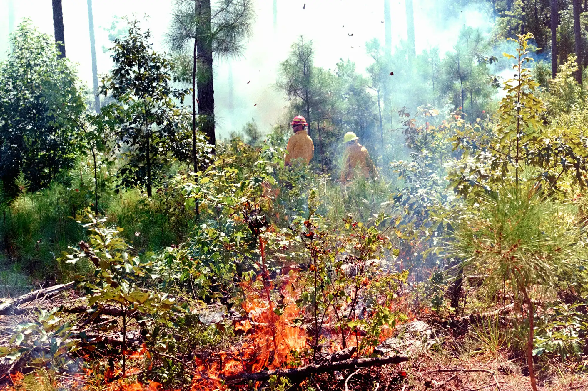
The third intervention was a pilot prescribed (controlled) burn to prevent uncontrolled wildfire, implemented over 4.84 ha after identifying suitable areas and training operators. Prescribed burning was framed as a nature-based solution that reduces fuel availability, removes or reduces fine and dead plant material susceptible to ignition, breaks vertical fuel continuity that helps fires reach canopies, and maintains or restores small open areas within and at the edges of forests. It was also treated as a silvicultural tool that can support selection of desirable species and alter stand structure to favour diameter growth and improve ecosystem stability. Because prescribed burning was not regulated by specific regional operational guidelines, local administrations began a shared pathway to explore how to address this legislative gap, and the project used the pilot to inform discussions on wider, full-scale applicability.

Key stakeholders

  • Capitanata Consortium
  • ARIA research centre, University of Molise
  • ATS Montemaggiore
  • Tecno Forest
  • D.R.E.Am. Italia
  • Lega Coop Puglia
  • Agriplan Innovation broker
  • Municipalities in Puglia and Molise
  • Environmental associations
  • Local action groups
  • Cooperative enterprises
  • Private landowners/private citizens
  • PEFC Italy
  • Regional Environment Agency ARPA Puglia
  • Puglia Region (PSR Puglia; regional forest/fire planning authorities)

Financial metrics

  • Funding sources
  • Puglia Rural Development Programme (PSR Puglia), Measure 16.2 (pilot projects and innovation through partner cooperation)
  • Budget

    • Total project cost: €498,550
    • Cost breakdown: €373,000 for implementation, €10,000 for monitoring, €19,250 for coordination, €96,300 for dissemination

    Outcomes

    Environmental

    • Prescribed burn pilot implemented on 4.84 ha to reduce fine and dead fuel, interrupt vertical fuel continuity, and maintain/restore small open spaces at forest edges and within stands.
    • Monitoring and inventory conducted across 85 homogeneous areas, subdivided into 23 m x 23 m cells, measuring indicators including tree density, species composition, biomass, diameter at breast height, and carbon stored in trees.
    • Forest management plan designed for a 10-year period, with a planned revision after 5 years, targeting enhanced fire prevention and mitigation of hydrogeological instability.

    Social

    • Establishment of a community of practice and the Forest Agreement, through which people living and working in the Occhito lake territory become the leading actors for the sustainable forest management transition.

    Economic

    • Information not available on delivered outcomes.
    • Cost reductions are expected from improved ecosystem services, fire risk reduction,
    • Revenue is expected from boosting local economies and rural development, among others due to the valorisation of wood products and using the forest for recreational activities and eco-tourism

    Risks and considerations

    • Prescribed burning faces a regional operational-guidelines gap in Puglia, limiting full-scale application despite being envisaged in regional legislation; this constrains scaling until guidelines are developed.
    • Preparing the forest management plan required significant preparatory work, in collecting information about land use constraints and local botanics, forestry, fauna and agronomics.
    • Implementation was delayed by adverse meteorological conditions affecting LiDAR data collection (Jan–Jun 2021) and by Covid-19 restrictions on fieldwork and social activities.
    • Project activities were concentrated on the Puglia side due to funding conditions, requiring deliberate effort to transfer results to Molise despite similar challenges on the western lakeside.

    Lessons learned

    • Establish a formal governance vehicle (such as a voluntary public-private agreement) to coordinate fragmented land ownership and ensure long-term implementation, monitoring, and accountability for forest management actions.
    • Invest early in a robust evidence base (combining field surveys with remote sensing such as LiDAR) to target interventions, justify prioritisation, and build confidence among administrations and landholders.
    • Anticipate regulatory bottlenecks for innovative practices (such as prescribed burning) and engage regional administrations early to develop operational guidelines that enable safe scaling beyond pilots.
    • Use a “community of practice” model to sustain stakeholder buy-in, link environmental objectives with local economic opportunities (e.g., short supply chains and eco-tourism), and support scaling across administrative boundaries.

    Sources

    Related EU projects

    Information not available yet.