Hide panel
Ecosystem type
Select
Thank you! Your submission has been received!
Oops! Something went wrong while submitting the form.
Land-use challenge
Select
Thank you! Your submission has been received!
Oops! Something went wrong while submitting the form.
NbS approach
Select
Thank you! Your submission has been received!
Oops! Something went wrong while submitting the form.
Clear allAbout the libraryGuide
Freshwater bodies and Rivers
Waterbodies degradation
Wetland and water management

Restoring River Processes to Reduce Flood Risk and Improve Ecology: Eddleston Water, Scottish Borders

Location

Eddleston and Peebles, Scottish Borders, Scotland, United Kingdom

Status

Project ended

Scale

Landscape level

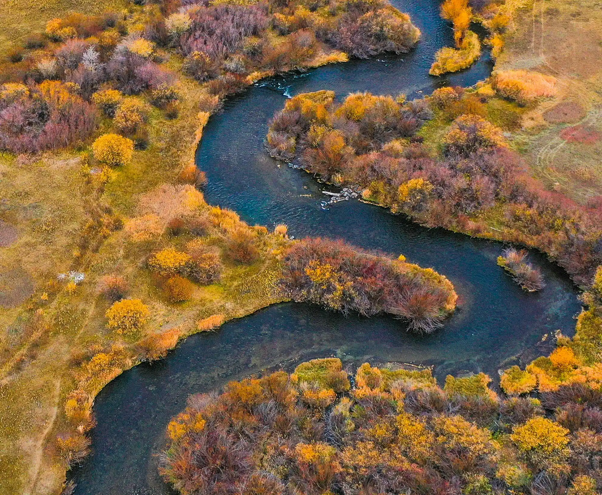
The Eddleston Water project is a long-term, catchment-scale programme using natural flood management (NFM) to reduce downstream flood risk while improving river ecology. Since 2009 it has partnered with farmers to re-meander >2 km of channel, plant ~200,000 native trees, install 22 ponds and 101 large-wood structures, and set up intensive monitoring. Early results show improved ecological status, local peak-flow delays, and strong modelled benefits from combined measures.

The 70 km² rural catchment was historically straightened and constrained by transport infrastructure and intensified land use, increasing downstream flood risk and degrading habitats. SEPA estimated 582 properties are at risk under an once in 200 years event. In 2009 the river was classified at ‘Bad’ ecological status (Water Framework Directive criteria). Water quality is generally good and the river is part of a Special Area of Conservation for salmon, lampreys, otters, and aquatic plants. The project was created to test whether working with natural processes across the catchment can meaningfully reduce flood risk, restore habitats, and be compatible with viable farm businesses.

Highlights

  • Catchment-scale NFM delivered with 20 farmers: >2 km re-meandering; ~200,000 native trees; 22 ponds; 101 large-wood flow restrictors.
  • Intensive empirical monitoring network (12 stream gauges, 1 weather station, 4 rain gauges) to evidence effects.
  • Ecological status improved from bad to poor, then to moderate.
  • The target is good.
  • Empirical delays in peak timing (30–60 minutes) associated with large-wood structures.
  • Modelling indicates five floodplain ponds in series can locally cut a 1.5-year peak by ~18–20% and delay it up to 6 hours.
  • Catchment modelling under an extreme afforestation + increased floodplain roughness scenario projects peak reductions up to 43% (20-yr RP) and 31% (100-yr RP), with 45–120 minutes delay.
  • Positive economics for riparian woodland: average benefit–cost ratio 12.5; ~£80k/year estimated benefits (full benefits after ~15 years).

Timeline

  • 2009 - 2010: Scoping study identifies NFM opportunities.
  • 2011: Monitoring network installed (hydrology, hydro-morphology, meteorology, ecology, groundwater).
  • 2012 onwards: Implementation and monitoring of NFM measures.
  • 2013 - 2014: First wave of works; voluntary agreements with landowners; re-meandering and initial features installed.
  • 2016: EU Interreg grant awarded; core support to 2020.
  • 2016: Most recent floods in area; communities escaped major impacts (attribution primarily to weather conditions; NFM contributed).

About the intervention

The project implements multiple NFM measures—re-meandering straightened reaches, installing leaky woody structures, creating ponds, and planting native woodland—distributed across the 70 km² catchment. These measures increase channel and floodplain roughness, create temporary storage, and enhance infiltration to slow, store, and filter floodwaters while restoring habitats. All works are underpinned by a comprehensive monitoring network to quantify hydrological and ecological responses.

Intervention details

Interventions were selected through an initial scoping study (2009/10) that identified a broad set of natural flood management (NFM) and habitat restoration options suitable for the Eddleston catchment. From 2011, a comprehensive monitoring network was installed to establish baseline conditions (surface hydrology, hydro-morphology, meteorology, ecology and groundwater). From 2012 onwards, measures were implemented and monitored using an empirical approach, including “Before-After, Control-Impact” study designs for key river restoration works.

Implementation on the ground was led by Tweed Forum, working as a trusted intermediary with local landowners and farmers. Staff walked the catchment to identify feasible locations and agree voluntary measures with no obligation for land use change. While some opportunities were not taken forward due to their importance to farm businesses, interventions were secured across 20 farms.

River re-meandering and channel restoration focused on reversing historical straightening that had increased flood risk and degraded habitats. Over 2 km (reported as 2.2 km) of straightened channel was re-meandered, adding around 300 m to the river length and generally widening restored sections. This was intended to slow flows and increase habitat quantity and diversity by reinstating more natural channel form and flow patterns. Monitoring of ecological response included habitat assessments and targeted work on salmonid habitat, with electro-fishing surveys undertaken before works and planned for repetition.

Water storage measures included creation of 22 ponds in the upper catchment. Pond water levels were measured to quantify storage performance. In addition, modelling examined the potential effect of a series of larger floodplain ponds, indicating how pond placement and sizing could influence local peak discharge and timing for smaller return-period events.

Flow attenuation measures using wood were implemented as 101 log structures (large wood flow restrictors/leaky dams), primarily in the upper catchment. Their effect was assessed empirically through observed changes in time-to-peak, and complemented by hydraulic modelling based on topographic surveys using HEC-RAS to test how the number of structures influenced flood storage and peak travel times across different flow magnitudes.

Woodland measures included extensive native tree planting across the project area (around 200,000 trees overall) and a specific 2-hectare native woodland planting in the Burnhead tributary catchment. At Burnhead, a small network of water level and flow monitoring points was established to provide baseline hydrological conditions against which future changes could be measured. Riparian management also included fencing to exclude livestock and tree planting at the Shiphorns re-meandering site, alongside monitoring of brown trout populations at both Burnhead and Shiphorns.

Key implementation challenges were primarily social and practical: measures depended on landowner willingness and had to be compatible with sustaining farming livelihoods. These were addressed through voluntary participation, site-by-site opportunity identification, and facilitation by Tweed Forum to support engagement and cooperation at landscape scale. Empirical monitoring was used to build locally relevant evidence of effectiveness, recognising that catchment-scale flood responses would take time to detect and that modelling would be needed to complement field measurements in the interim.

Key stakeholders

  • Project management: Tweed Forum
  • Project Board: Scottish Environment Protection Agency (SEPA), Scottish Government
  • University of Dundee
  • Scottish Borders Council
  • British Geological Survey
  • Scottish Natural Heritage
  • National Farmers Union of Scotland
  • Scottish Land & Estates
  • Forestry Commission
  • Tweed Foundation
  • Scottish Government
  • SEPA’s Water Environment Fund
  • Scottish Rural Development Programme
  • EU Interreg
  • Private/charitable contributors
  • Local farmers and landowners
  • Eddleston community.

Financial metrics

Funding sources

  • Scottish Government
  • SEPA Water Environment Fund
  • Scottish Rural Development Programme
  • EU Interreg (grant awarded 2016, core support to 2020)
  • Private/charitable contributions

Budget

  • £723,000 in direct costs secured for interventions on 20 farms
  • Information not available on total programme budget beyond the above

Outcomes

Environmental

  • Ecological status improved from bad to poor to moderate (WFD classification) with an aim of good.
  • Empirical delay to peak flow of 30–60 minutes linked to large-wood structures.
  • Modelling: five floodplain ponds in series could reduce a 1.5-yr peak by ~18–20% and delay by up to 6 hours.
  • Catchment model (extreme scenario with total hillslope forest cover + increased floodplain roughness): peak reductions up to 43% (20-yr RP) and 31% (100-yr RP); peak delays of ~45 minutes (20-yr RP) and ~120 minutes (100-yr RP).
  • Rapid macroinvertebrate recolonisation; increased physical habitat diversity; potential increase in salmon spawning micro-habitats post-re-meandering.
  • Two hectares of native woodland planted in a tributary to enable hydrological baseline tracking.

Social

  • 20 farms engaged via voluntary agreements.
  • 582 properties identified at flood risk under a 1:200 scenario.
  • Use of a “trusted intermediary” (Tweed Forum) identified as critical to landowner participation.

Economic

  • Riparian woodland measure: estimated ~£80k/year benefits; average benefit–cost ratio 12.5; positive net present value under all tested climate scenarios (full benefits after ~15 years).
  • Interventions on 20 farms delivered for ~£723k direct costs.

Risks and considerations

  • Ecological and hydrological responses can lag; whole-catchment flood-signal changes may take years.
  • Achieving “Good” ecological status depends on further land-use change acceptable to landowners.
  • Local groundwater dynamics can sustain high levels near floodplain margins, creating potential for local groundwater flooding under saturated conditions.

Lessons learned

  • Governance & delivery: A trusted intermediary (e.g., catchment partnership) is essential to broker voluntary agreements, align measures with farm operations, and secure landscape-scale deployment.
  • Monitoring & evidence: Install robust baseline networks and use BACI designs to evidence effects of individual measures while modelling catchment-scale outcomes that take longer to emerge.
  • Scale & mix matter: Meaningful flood-risk reduction requires many NFM types applied widely across sources, pathways, and receptors; single features provide localised benefits.
  • Economics & co-benefits: Appraisal should include multiple ecosystem services; measures like riparian woodland can show high benefit–cost ratios and positive NPV even before full flood benefits materialise.

Sources

For Reference

  1. Interreg North Sea Region, Building with Nature, 2016.

Related EU projects

Information not available yet.